Examples Example 4 of 4
Example 4 · Olney, Montgomery County, Maryland
A small lot, the aerial photograph check and a quick check
The job. A homeowner in Olney, Montgomery County, Maryland, wants a house addition and a wider driveway on a 0.71 acre lot. Before that, they asked whether a back yard patio and shed would matter at all.
About this example
This is a real run on app.curvenumber.com, made under the CurveNumber Examples account. The place is real. The homeowner and the house location survey are fictional, and the run says so wherever they are named.
What this example shows
- What CurveNumber says when a site is too small for the national land cover map.
- The aerial photograph check: reading hard surface and planting off a 1 m photograph, and accepting it under your name.
- Building the existing condition from the photograph.
- A quick check, and the small area rule that stops it from reporting a curve number answer on a very small area.
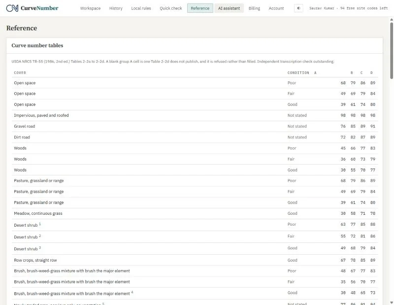
- The Reference page with the TR-55 tables.
01A site smaller than the map
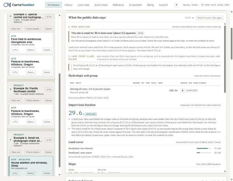
The land cover map reads the ground in 30 m squares, and this lot is about 3 of them. CurveNumber marks the land cover as thin and says why: one square read as the wrong class would move a cover share by about 31 percent of the site. It suggests the aerial photograph check, or entering the surfaces by hand.
02The aerial photograph check
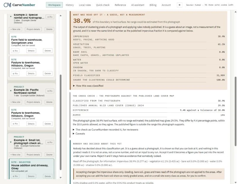
Classify the photograph fetches the public domain aerial photograph of the lot (here flown July 12, 2023) and sorts its pixels into hard surface, planting, bare soil, water and shadow. On this lot it read 38.9 percent hard surface. It then compares that with the land cover map (29.5 percent), within the 10 point tolerance.
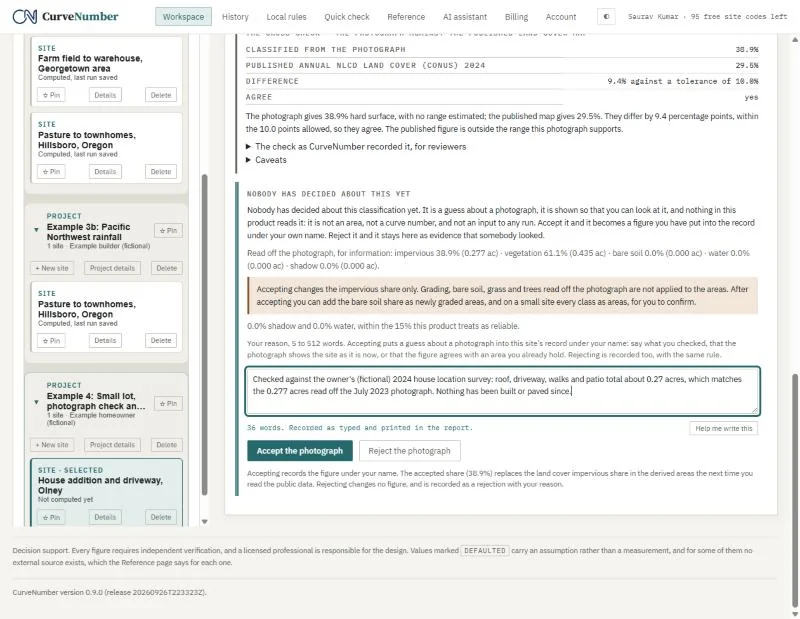
CurveNumber is plain that this is a guess about an image, not a measurement of the ground. Nothing uses it until a person accepts it with a reason.
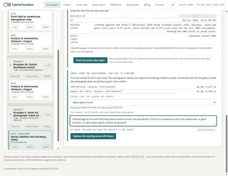
We accepted it, noting that a (fictional) house location survey gives about 0.27 acres of roof, driveway, walks and patio, against 0.277 acres read off the photograph. The acceptance is recorded with the name, the time and the photograph it applies to.
03Areas from the photograph
On a small site the photograph's classes can replace the existing areas. The photograph cannot tell grass from trees, so you choose the cover for the planted part (we chose open space in good condition, a mowed lawn) and confirm with a reason. The soil group comes from the soil survey (group B here).
04The addition and driveway
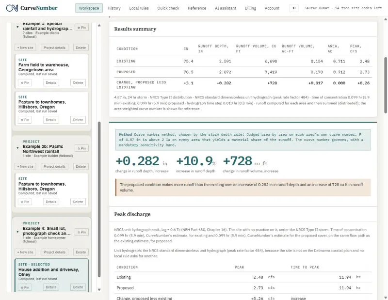
The proposed condition adds 0.060 acres of roof and paving and takes the same area out of the lawn. At the 10-year, 24-hour storm (4.87 inches, NOAA Atlas 14):
| Curve number | Runoff depth | Runoff volume | Peak | |
|---|---|---|---|---|
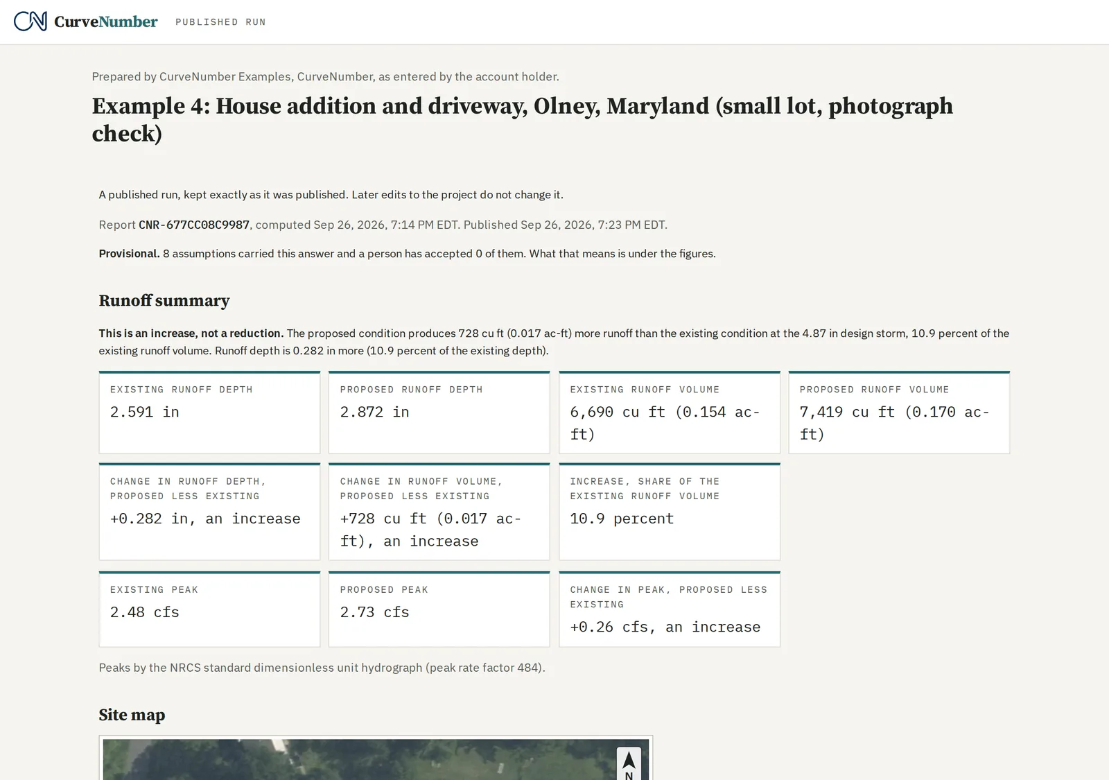
| Existing | 75.4 | 2.591 in | 6,690 cu ft | 2.48 cfs |
| Proposed | 78.5 | 2.872 in | 7,419 cu ft | 2.73 cfs |
The addition adds about 730 cubic feet of runoff in that storm. We checked both depths by hand.
The published example
The house addition and driveway, published: a fixed, read-only page with the full report, exactly as it was published. It needs no account.
https://app.curvenumber.com/p/6dJRYt_bZwus57VwoGpC7iXLks4ppxQs
05A quick check, and the small area rule
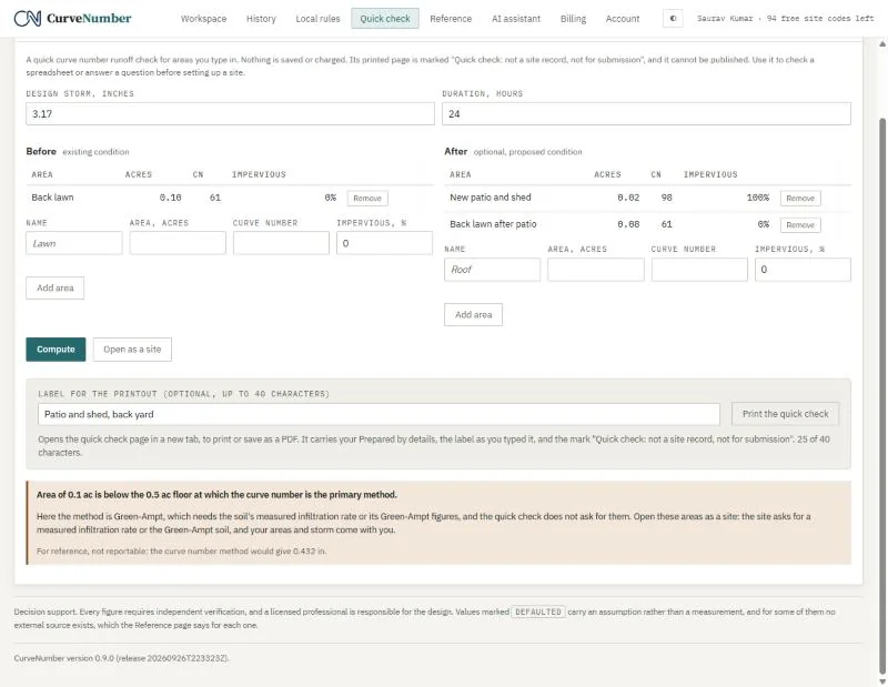
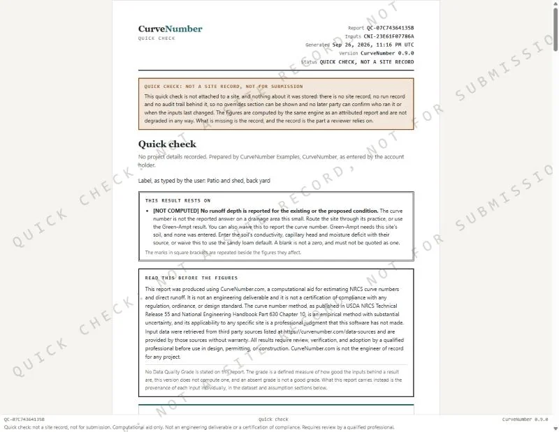
Quick check answers a question without setting up a site. You type the storm and the areas, before and after; nothing is saved or charged. Here: a 0.10 acre back lawn, of which 0.02 acres becomes a patio and shed, at the 2-year storm (3.17 inches).
CurveNumber would not give a curve number answer. Below 0.5 acres it treats the curve number as the wrong primary method and asks for Green-Ampt instead, which needs the soil's measured infiltration or its Green-Ampt figures. It still shows the curve number figure for reference (0.432 inches for the lawn), labeled not reportable, and offers Open as a site to carry the areas and storm into a full site.
The printed quick check says on every page that it is a quick check, not a site record and not for submission, carries your Prepared by details and the label you typed, and cannot be published.
06The Reference page
Every curve number CurveNumber reads out of TR-55 comes from the tables on the Reference page, by cover, condition and soil group, with the edition named.